Day 1: Monday, 17 June 2013

From Priwall to Gorleben
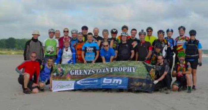
Things got off to a punctual start at Priwall beach at what is now the border between the German states of Mecklenburg-Vorpommern and Schleswig-Holstein. Shortly before 8 am all 32 participants lined up for the group and individual photographs. The snaps were used to identify the participants on the Overnighter website when they phoned in each evening with their location details and progress reports. It was a cool morning. I donned my mittens, buff and balaclava. Then somebody blew a whistle (or perhaps I imagined that) and we all set off together.
Priwall — on the border, 17 June 2013
The first 100 meters or so involved pushing the bikes through sand dunes at a snail’s pace. This made me immediately reconsider my calculations as to how long it would take me to complete the entire trip. I had set myself a personal limit of eight days, or a total of 192 hours, although the Self Supported Ride Codex does not specify a maximum time and theoretically one could finish the course in six months using a rollator — and yet be deemed to have succeeded in purely formal terms. But — I said to myself — 8 days is a realistic objective. My reasoning was based on the time limit for completing the quadrennial 1200 km Paris-Brest-Paris randonnee, which is 90 hours. I had finished it in just under 85 hours in 2011. The PBP brevet is the same distance as the Grenzstein Trophy. In my own (rather limited) MTB experience, one kilometer off-road was broadly equivalent to two on-road in terms of energy expended. So riding an MTB along a 1200 km track consisting of a mix of surfaces such as dirt roads, forest paths and single trails should hardly take more than twice as long as the same distance on tarmac. Ergo, the GST should be ‘doable’ by a fit cyclist in just over a week — something like the PBP twice in succession, perhaps with a 12-hour rest and recuperation break somewhere in the middle. My objective was to arrive at the trijunction between the former BRD, the former DDR and former Czechoslovakia at the latest on the morning of Tuesday 25 June. After all, what able-bodied cyclist couldn’t manage an average speed of just over 6 km per hour?
But what if there was more sand and mud than I had bargained for? And what if I were to be beset by navigation problems? Hardly had we set off from Priwall than I began to have my doubts: perhaps the GST was more equivalent to three PBPs than to two!
There was also the GST’s bete noire: the all-weather patrol roads (Kolonnenwege in German). These patrol roads were constructed along the entire length of the frontier to facilitate rapid access by the East German army and border guards. They consist of two rows of three-meter long perforated concrete slabs embedded in the earth, with an 80 cm wide gap in the middle. The nature of these slabs — from the cyclist’s perspective — has been best described by Henri Lesewitz in his book entitled Endlich Rasen:
“The design principle of the concrete slabs does the rest. It perfectly matches that of a bicycle dock: two parallel lattices — the width of a hand towel — with cutting board trenches that make the mountain bike vibrate beneath the rider as though it were a bull-riding machine. The frame does its best, but it just isn’t up to the task. Riding downhill is hardly any faster. Each trench in the cutting board can lead to a fall.”
More about the patrol roads later.
And now back to the navigation saga. At first all went well because I didn’t even have to use my iPhone app at all. The group was so closely bunched up as far as Ratzeburg that I could rely on the cyclists ahead of me, all of whom seemed to have perfectly functioning navigation systems — mainly the Garmin eTrex 30 — and had obviously had no problem in downloading the GST track onto their computers. However, I noted that the blue blob on my iPhone’s display screen was not always on track but running in parallel at a distance of up to 20 or 30 meters. How come? How would I manage when I no longer had the support of other cyclists’ navigation skills?
Later in the morning the sun came out as we cycled through the magnificent heathlands of Mecklenburg-Vorpommern in the Northern German plain. At a temperature of 20 degrees and an average speed of 15 km/h, all was going swimmingly — though there were enough sandy stretches to bog one down occasionally. Then came a particularly ‘easy number’ after we crossed over into Schleswig-Holstein to the west of the Ratzeburger See. It was only after Ratzeburg that the group thinned out somewhat and soon most of us were travelling at our own pace, with me pretty much in the rear.

Civilisation ahoy! — from the long-distance cyclist’s perspective
Eventually I arrived at the Elbe a few kilometers east of Lauenburg and was happy to find that the route now ran along an asphalted road, the B5. But soon I noted that the location blob on my iPhone’s display screen was gradually but inexorably shifting away from the track. I had to turn back and discovered that the course had veered off road to the right at an almost imperceptible gap in the trees. Then came my first real taste of the all-weather patrol road on a 7% incline.
I arrived at Boizenburg on the Elbe at around seven pm. Because of the disastrous flooding in late May and the temporary ban on cycling along the Elbe dykes or anywhere in the vicinity of the floodplain, an alternative course (segment 3) between Boizenburg and Doemitz on the right bank had been chosen to replace the original track that ran along in close vicinity to the river’s left bank. The new segment was approximately 20 km shorter — and consisted largely of asphalted road. This probably cut several hours off the journey. No doubt the purists among the participants (and they were almost all purists) were somewhat unhappy — the very sight of asphalt makes many mountain bike fans almost physically sick, since it falls foul of their most basic tenet: why do it the easy way, when the hard way is so much more difficult? But as an MTB rookie I still believed that a little bit of tarmac never did any harm.
After stocking up with water I headed on towards Doemitz and then coasted along the B191 across the Elbe to Dannenberg, where I arrived at about 8:30 pm. . If I could keep up this rate of progress I would finish the GST in seven days! It was not to be. Soon I had my first encounter with the navigation’s devil.

When Nature sucks
Water, water, everywhere — view from the Elbblick, Boizenburg
Outside Dannenberg the alternative Segment 3 came to an end. So I opened the Segment 4 file of the GST track — in my iPhone app all 20 segments were in separate files, and so there was no way I could get an overview of the entire route on the display screen. There was a gap between both segments. WTF? The alternative segment ended just after the intersection between the B191 and the L256 to the east of Dannenberg. WTF? But Segment 4 did not start until after Gusborn, about 10 km to the east. WTF? How was I to bridge the gap? WTF? Surely the scouts had made an error.
I was flummoxed. First I cycled north towards the village of Seybruck — there was no other road to take apart from the L256 but that would certainly have been deemed cheating since it led straight to Gusborn — and the straight path is always the crooked one in the perverse morality of the MTB community. After several kilometers I arrived at a barrier and a warning saying that the road was closed due to flooding. But I cycled on — perhaps the waters had receded in the meantime, I thought. They hadn’t. There was no option but to turn back. I was no amphibian. So it was back, forward, North, South, East and West. Eventually I ended up in Quickborn (I think) and managed to get to Gusborn (I think), which was within spitting distance from the starting point of Segment 4. I was fortunate enough to find a restaurant that was still serving food at half past nine.
By the time I had stuffed myself to the gills night had fallen. I didn’t feel the slightest tired. So I decided to cycle on through the brief midsummer night and sleep only if overcome by exhaustion. I had cycled overnight before on several occasions — during PBP 2011 and a preparatory 600 km brevet, and during the 1000 km Negev Desert/ Dead Sea Brevet in Israel which I had completed six weeks previously — but this was the first time I cycled quite alone off pavement from dusk to dawn. It was a truly exhilarating experience — with my Magicshine MJ880 front light occasionally at full blast (2000 lumen) whenever I needed perfect vision.

Let there be light … the MJ880 in action
Sometime the next morning when I was halfway through the Altmark I realised why I had gone off course. The error had been mine — instead of consulting the Segment 4 file I should have opened the original Segment 3 file, since the alternative route had terminated where it merged with the old one. There was no gap.
At first blush the Self-Supported Ride Codex seems to be quite unambiguous about this: if you accidentally cycle off track even for the shortest distance (e.g. 50 meters) , you must — once you discover your error, which may be a lot later as in my case — return to the point from which you initially strayed and cycle the correct route. Even a high court judge would have had difficulties in interpreting this rule to mean, say, the opposite to what it said.
But did I return to cycle the 10-km tail end of Segment 3 between Dannenberg and Gusborn which I had inadvertently skipped eight hours previously? You can I bet I didn’t. And I gradually began to introduce a number of amendments to the Codex: yes, the act of deviating from the true path (in this case, the GST track) was a grave and serious matter. OK — I did not have full knowledge at the time I committed the act; and I did not give the full consent of the will. There was, in other words, no intentionality. But that is no excuse — an error is never intentional. Still, it was not as though had I cycled straight along the fast road to Gusborn with the gay abandon of a hardened sinner. It is plain and simple, I said to myself: as it stands, the Codex’s rule in this particular context falls foul of the natural order of things. Phoquit.
The next ‘shit happens’ incident occurred early on Tuesday morning. Around dawn and after cycling for three hours through forest paths and equestrian trails I arrived at a devilish crossroads in the middle of the woods where the paths led off in five or six directions, some of them petering out into single tracks that in turn seemed to fade away into non-existence. Besides, the blue blob on the display screen indicating my location seemed to take on a life of its own and started moving to and fro even when I was motionless. WTF? And all the real existing paths were off track. The blob simply wouldn’t stay on the track in the display screen but kept wandering off no matter what direction I cycled in.
Anyhow, after what seemed like an eternity of cycling hither and thither, I eventually managed to thrash my way through a tangled mass of undergrowth, brambles and tree stumps to arrive at a brook which, at least as indicated by my fickle navigator, was actually on track and definitely had to be crossed. There was no bridge, however. WTF? The brook was too wide for my demographic to even think of jumping over, with or without bike and baggage. So, to avoid getting my feet wet, I emptied my two stuff sacks, put them over my shoes and waded gingerly across. My feet remained dry. In memory of this adventurous interlude I wrote a note on a scrap of paper informing all subsequent GST cyclists that ‚Charles was here‘ and posted it on a twig that hung out over the trail beside the brook. What with emptying, donning, removing and refilling the stuff bags, the entire operation held me up for at least half an hour.
Shortly after sunrise I was overtaken by two other cyclists — David, I think, and another Jungspund. They had camped for a couple of hours in the vicinity of Dannenberg — and yet already they had caught up with me. Their average cycling speed was clearly a lot faster than mine. But I had the advantage of being an insomniac. At least for a few hours I was (I think) one of the first.
For a few minutes the three of us cycled along together. My pulse soon reached its limit of 160 and indeed I was almost at the end of my tether before you could say ‘VO2 max’ — though of course I tried to converse casually as though cycling in the company of a couple of fit thirty-somethings was as easy for me as falling off a log. All is vanity, saith the preacher. A generation goes, and a generation comes.
Shortly we spotted a couple of small furry creatures on the side of the track. From a distance they resembled a pair of cats. As we approached we saw that they were in fact badger cubs, who clearly disapproved of their territory being invaded by aliens. Like a couple of sentinels they stood side by side and chirped and twittered incessantly, hissing aggressively as we dismounted to observe them. Then one of the demented creatures lunged forward and bit my front tyre. I decided not to risk a flat and cycled on, abandoning the two younger cyclists to their fate. They overtook me ten minutes later.
Is there a lesson to be learnt from this incident? Was this the European equivalent to an encounter with a grizzly bear or mountain lion on the Tour Divide along the Rockies? I had reckoned with a rabies-infected stray dog or wild boar as the worst possible brush with Europe’s fauna. But who could predict a badger cub attack? The lesson is that the only thing that is certain about the Grenzstein Trophy is that it is going to be full of surprises. Man proposes, the GST disposes.